


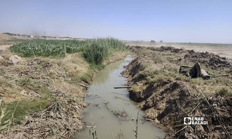
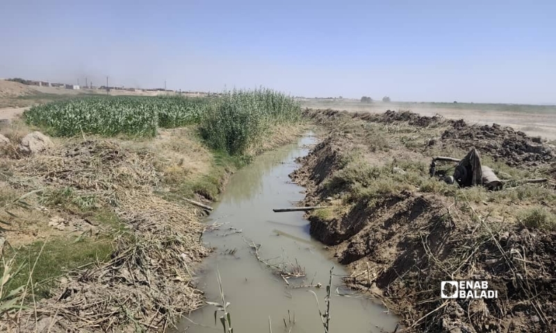
 Work to clear the Balikh River channel opposite al-Hamrat, in the eastern Raqqa countryside, September 3, 2026 (Enab Baladi)
Work to clear the Balikh River channel opposite al-Hamrat, in the eastern Raqqa countryside, September 3, 2026 (Enab Baladi)
Enab Baladi, Shaaban Chamieh
An unprecedented environmental disaster is unfolding along the natural river channel that winds eastward below the villages of al-Hamrat (Raqqa governorate, northeastern Syria), where the Balikh River turns in its final stretch before flowing into the Euphrates at Hamra Nasser village.
With most of the river’s water diverted into drainage channels north of al-Samra, flow in its lower reaches has fallen to critical levels. Its final stretch now faces severe pollution, rising salinity, and an absence of dissolved oxygen, leaving the water biologically dead and killing its aquatic life.
This channel, now a stagnant environment unable to sustain healthy life, was once an abundant, clean waterway whose banks supported some of the earliest civilizations and centers of international trade. From the historic site of Tell Zeidan to Tuttul (Tell al-Bi’a), which directed eastern caravans toward Mesopotamia and Emar in the third and second millennia BCE, the Balikh’s waters were a primary source of life, praised by historians.
Today, amid a dry climate and scarce rainfall, this cultural and environmental heritage stands on the brink of disappearing. The historic river’s final stretch has become a swamp struggling against the loss of both water movement and biological life, threatening to erase its remaining vegetation and geographical identity.
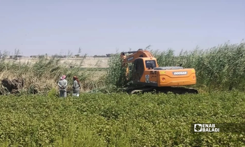
Work to clear the Balikh River channel opposite al-Hamrat, in the eastern Raqqa countryside, September 3, 2026 (Enab Baladi)
Environmental researcher Ahmed al-Wajid told Enab Baladi that the sharp decline and fluctuations in water discharge along the Balikh River’s final stretch begin immediately where the natural channel separates from the drainage channel.
Al-Wajid said the problem lies not in the existence of the drainage channel itself, but in the absence of precise mechanisms to regulate how water flow is distributed. The channel takes most of the water because of its depth, cross-sectional area, and high discharge capacity, allowing it to control the entire hydraulic flow path.
Without an established water allocation guaranteeing a continuous minimum environmental flow in the natural channel, temporary engineering measures remain fragile. These include relying on an unstable stone barrier to raise the water level, even as natural forces and the passage of time continually erode and dismantle it.
The researcher added that direct human interventions place further pressure on the channel. These include deliberately removing stones and diverting water into drains and secondary channels at the beginning of this stretch.
Some of these newly created channels appear deeper than the natural riverbed after being widened to increase their capacity to convey water. They consequently capture almost all the flow, particularly when water levels are low.
These encroachments sharply reduce the water supply reaching the middle and final sections of the river, completely interrupting flow and turning large areas into stagnant, lifeless pools.
Field observations documented by al-Wajid reveal the complete absence of a clearly defined protected river corridor to prevent encroachments. Interrupted flow and a dry riverbed have encouraged residents to use the low-water channel as crossing routes and dirt roads, while farmland has expanded and excessive plowing has extended directly to the riverbanks.
The study warns that these unregulated practices worsen conditions by filling in the channel, narrowing its passage, and increasing sediment deposits in the riverbed. This undermines the river’s ability to recover its hydrological and ecological functions naturally, even if flow returns in the future.
Al-Wajid stressed that addressing these adverse hydromorphological changes, affecting water conditions and channel shape in both the drainage channel and the natural riverbed, requires urgent engineering action. Water distribution must be reorganized, with some of the water diverted into the drainage channel pumped back into the original riverbed to ensure a continuous minimum environmental flow capable of reviving it.
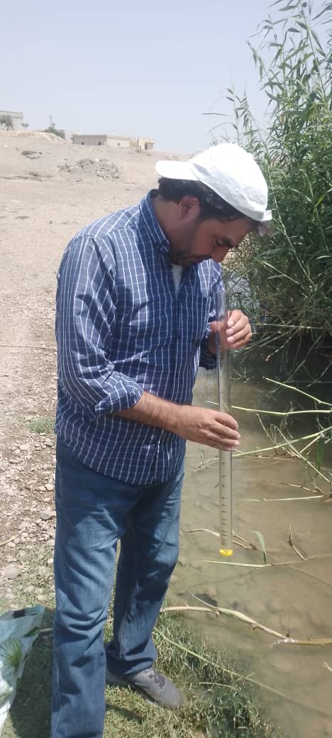
Environmental researcher Ahmed al-Wajid taking field measurements at the Balikh River in Raqqa governorate
Historical evidence documented by environmental researcher Ahmed al-Wajid, including photographs of the Balikh River’s natural flow a quarter of a century ago, aligns with older residents’ accounts and recent field observations. Together, they reveal the scale of the profound, continuing transformation of the river’s ecosystem.
Documented accounts indicate that, until the early 1990s, the Balikh’s water was suitable for drinking and household use, sustained by abundant freshwater springs.
As these feeding springs dried up, the river underwent a dramatic transformation. Its historic channel became a conduit for agricultural drainage and sewage, sharply increasing its salt content. Measurements from the beginning to the end of this stretch recorded environmentally hazardous levels ranging from 1,220 to 1,450 parts per million. This was accompanied by a shallower channel, stagnant water, and accumulated muddy sediment, particularly at the final bend leading to the Euphrates.
This deterioration severely disrupted the river’s biological communities and surrounding vegetation. Once home to a rich, resilient range of plants, including licorice, Syrian mesquite, camelthorn, and numerous other thorny plants, the river has lost that diversity, giving way to the complete dominance of common reed.
Al-Wajid explained that natural vegetation plays a crucial role in stabilizing surface flow and limiting changes to the riverbed’s shape.
The damage has also affected the balance of animal life. The newly stagnant environment has driven away creatures that older residents recall being abundant, including river turtles, fish, and wild birds such as geese, ducks, pelicans, starlings, and sandgrouse.
The researcher warned of the dangers posed by the disappearance of these birds, which serve as a first line of ecological defense in this agricultural environment because of their vital role in consuming insects and rodents that damage crops.
Taken together, these indicators suggest that the river is undergoing severe “retrogressive succession,” reshaping its natural habitats and plant communities toward degradation and desertification.
The rapid deterioration of water quality compared with the river’s past is among the clearest documented signs of environmental decline. Reduced discharge and interrupted flow have coincided with polluted agricultural drainage entering the main channel directly, including discharge from the drain between Hamra Ghannam and Hamra Buwaytiyah villages.
To provide an accurate assessment based on scientific measurements, al-Wajid examined the water’s physical and chemical characteristics by collecting and analyzing approximately 28 samples of river water and nearby groundwater.
The field assessment used digital and laboratory testing tools, including a multifunction digital water-quality tester, laboratory urine test strips, and a manual chlorine and pH testing kit.
It also included detailed qualitative testing for toxic nitrite compounds at two different locations in the lower reaches. According to the researcher, these tests provided laboratory evidence of the biological and chemical death of the Balikh River’s final sections.
The researcher said his field and laboratory assessment revealed a troubling environmental paradox: groundwater wells surrounding the river generally recorded higher electrical conductivity and dissolved solids than most river samples.
According to al-Wajid, this finding underscores the critical importance of preserving a sustainable river-water resource with relatively lower salinity for agricultural use, protecting the soil against rapid salinization.
These risks are compounded by the continuous sewage flows observed entering the channel, particularly after nearby residents began directing discharge from numerous household cesspits straight into the river without treatment.
Chemical analyses confirm this mixing of pollutants. Qualitative testing for toxic nitrite compounds produced a clear positive result in the drainage sample and in the sample collected where the discharge meets and mixes with river water at the bridge.
Based on these findings, al-Wajid believes the drain now receives a mixture of fertilizer-laden agricultural drainage and contaminated household wastewater. This has spread the pressure from toxic nitrogen compounds across other extensive areas, threatening both surface-water and groundwater reserves.
The disaster extends beyond water quality, interacting adversely with the physical properties of the area’s soil, which is predominantly clayey at several locations.
Al-Wajid said repeated field inspections showed pronounced swelling of soil particles when saturated with water, followed by severe shrinkage and deep cracking during dry conditions and periods of limited water flow.
The danger of this physical property lies in its direct effects: reducing water permeability, obstructing aeration around plant roots, and encouraging salts to move upward toward the surface.
According to the researcher, these structural changes hinder conventional farming operations and increase crop stress. They require the relevant authorities and farmers to adopt carefully controlled and monitored irrigation and drainage management to prevent the loss of farmland surrounding the Balikh’s final sections and its transformation into lifeless saline land.
The Balikh River’s environmental deterioration extends beyond the water directly into adjacent farmland. In sections still reached by the river, farmers are forced to irrigate from stagnant pools thoroughly contaminated with agricultural drainage and sewage. Weak flow has deprived the river of its natural ability to renew its water and dilute toxic substances.
In the final sections, where the channel has dried up completely, farmers face a harsh reality: the river’s absence has forced them to depend entirely on shallow groundwater wells.
The environmental researcher said his field measurements and laboratory tests confirmed sharply higher salinity and dissolved solids in these wells than in the river, placing severe salt stress on farmland.
Without effective drainage networks, salts have accumulated around plant roots and soil productivity has declined. This was observed in yellow maize fields suffering from stunted growth and discoloration.
Al-Wajid believes the most immediate lifeline is a return to river water. Despite its moderate salt content, it remains a less damaging option than groundwater.
However, the predominantly clayey soil and high evaporation rates impose strict constraints, particularly given the risk of nitrogen-based and microbial pollutants moving from cesspits and the Faij Sabha drain into fields. This raises concerns about disease passing from the water into crops and then to people.
The field study’s findings indicate that saving the Balikh River’s final stretch requires urgent action to secure a continuous minimum “environmental flow” in its natural channel.
This flow would do more than provide farmers with less saline irrigation water. It would improve water movement, increase oxygen levels, and reduce stagnation and the concentration of salts and toxic substances on the riverbed, helping restore ecological balance to vegetation and aquatic habitats.
Water scarcity is not the river’s only problem. Al-Wajid documented how parts of the riverbank near Hamra Ghannam Bridge have become an informal dump for household waste discarded by residents. The waste has reached the channel itself, damaging the natural landscape and creating additional health risks.
The environmental researcher concluded that removing these dumps and controlling encroachments are direct responsibilities of local municipalities. He called on them to act immediately and use their powers to halt the deterioration and restore the region’s historic waterway.
The environmental researcher stressed that halting environmental and agricultural losses in the Balikh River’s lower reaches requires an immediate shift from documenting the crisis to implementing sustainable engineering and environmental solutions. His main recommendations are:
– Secure environmental flow: Guarantee a continuous minimum water flow in the natural channel and regulate diversions into the drainage channel to prevent the final stretch from drying up.
– Engineer water distribution: Build a permanent, properly engineered water-control structure to regulate allocations, replacing temporary stone barriers vulnerable to erosion and collapse.
– Clear the channel selectively: Regularly remove muddy sediment and dense reed growth that obstruct water movement, while preserving the vegetation needed to stabilize the banks and support biodiversity.
– Prohibit uncontrolled wastewater discharge: Prevent cesspit effluent and untreated household wastewater from entering the river or agricultural drainage channels, and enforce strict monitoring of pollution sources.
– Conduct regular monitoring and inspections: Regularly measure river and groundwater quality and soil salinity by tracking electrical conductivity, nitrite, and oxidation potential, while adding laboratory bacteriological tests.
– Protect the river corridor: Enforce strict legal protection for the river corridor and stop unregulated plowing, filling, and agricultural encroachments that narrow and dry out the channel.
– Improve irrigation practices: Reduce reliance on stagnant water or water mixed with wastewater for crop irrigation, and develop effective agricultural irrigation and drainage systems that prevent salts from accumulating in the soil’s root zone.
– Adapt crop choices: Gradually shift affected sites toward suitable, salt-tolerant crops such as barley, replacing yellow maize, which requires freshwater and a regular water supply.
– Strengthen local action: Assign municipalities and local authorities responsibility for regularly cleaning the bridge area and riverbanks, installing warning signs, and imposing fines for dumping waste, alongside community awareness campaigns.
– Pursue comprehensive protection: Treat the Balikh River’s protection as an urgent environmental, agricultural, and historical necessity. Continued drying threatens to destroy natural habitats, agricultural production, and the archaeological and cultural sites associated with the river.
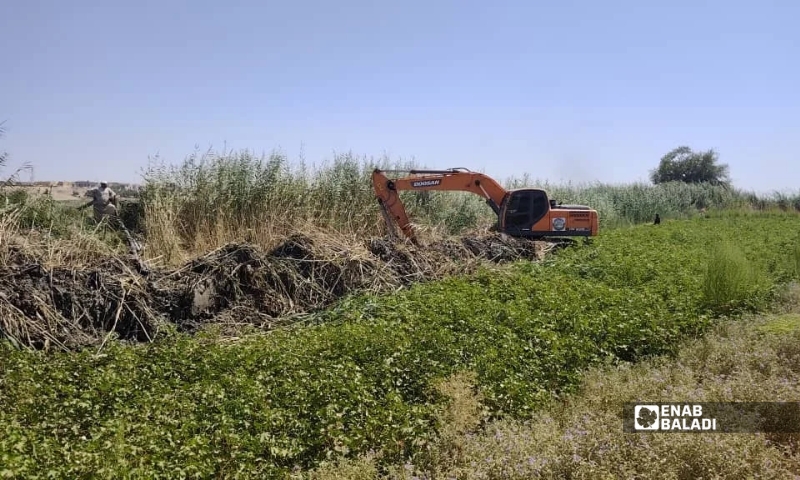
Work to clear the Balikh River channel opposite al-Hamrat, in the eastern Raqqa countryside, September 3, 2026 (Enab Baladi)
if you think the article contain wrong information or you have additional details Send Correction


 A
A
A
A
A
A






 More Society