


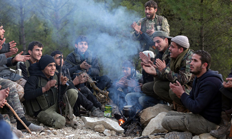
The “Free Army” Prepares to Enter Afrin


 A
A
A
A
A
A

The military map in Afrin area, in northern Aleppo, has witnessed massive changes and development, 50 days after the launch of the “Olive Branch” operation; most of the developments ended in the interest of the “Free Army” factions, backed by Turkey, which are at the very gate to the center, and are already preparing to take it over; accordingly, they are ready to defang the (Kurdish) “People’s Protection Units” in its most prominent strongholds in western Syria.
In the past a few days period, the military action was condensed at all axes, and the “Units’” fronts experienced an elaborate withdrawal, particularly at the western and eastern axes, for the “Free Army” factions reached control over the total space of the “strategic” Jindires area, and went deep at the Sharran axis, arriving at a distance of less than one kilometer from the area’s center, to add five districts to its military accountــــ districts that form the principal “defense line.”
Military sources from the “Free Army” told Enab Baladi that the military operations, currently, are directed with the aim to circulate Afrin’s center in a holistic manner, pointing out to “a serious and strong effort to arrive at the center.”
They also explained that the present map is manifested through dividing the areas under the control of the “Units” into two parts ـــNorthern and Southernــــ through joining the Sharran and Jindires axes, as a step to force the Kurdish forces to withdrew their forces from the Arab towns alongside the “Euphrates Shield’s” areas, including Tell Rifaat, Mebaatli district and the towns surrounding it deep in the area.
According to the field control map, the “Free Army” factions’ progress applies to all axes; nevertheless, the two major axes are Sharran and Jindires, to which great expectations are assigned, being the eastern and western gates to the center of Afrin area.
Until Saturday, March 10. 2018, the “Free Army” reached the town of Kheurbet Khaldiye at the southeastern side of Afrin’s center after it controlled the following towns: Maryamin, Inab, Shawarget al-Joz, Maardaset al-Khatib, trying to join its progressive forces at the Jindires axis, which entered both towns of Talaf and Kafr Zita, shrinking, thus, the distance between the two areas to less than ten kilometers.
As a milestone, the “Free Army” factions controlled the Suleyman Shah mountain and the two areas of Qibar and Qarah Tabbah, crushing down all the defense fronts in the eastern and northern sides of Afrin’s center and the “Olive Branch” fighters are one kilometer away from the center.
The Lieutenant Colonel Abdel Moneim al-Nansan, a military leader in the “Free Army,” in an interview, explained that the collapse of the forefront of the “Units” is the major reason behind the “Free Army’s” grand progress, after it managed to control the border line and the centers of the districts, which are followed by smooth geographical nature, if compared to the rigid border areas.
The progress, however, is not limited to this, for the weather also played a sufficient role. Al-Nansan referred to weather changes which differed from the first days of the “Olive Branch” operation, adding another reason to the pack that lies in the “moral devastation of the Unit’s fighters, and their feeling that the end is close.”
The current phase, after reaching the gates of Afrin’s center, according to the military leader, centralizes on fortification and military supervision, as well as securing all the towns around the center, to shift the battles’ focus to delve in the center’s depths.
“SDF” is Baffled
At the other side, the “Syrian Democratic Forces” (SDF), did not admit their withdrawal from the areas which the “Free Army” announced controlling; rather, their statements concentrated on reporting the artillery shelling and the air raids that targeted the residential neighborhoods in Jindires, Rajo and the city center.
Within the same context, SDF has declared, on March 6, that it sent 1700 of its fighters in the eastern areas, which it controls, towards Afrin to block the two armies’, the Turkish and the Free Army, progress. But the deceleration was not officially confirmed, to only exist as speech by a leader which “Reuters” Agency quoted.
After the announcement, the US declared that it already knew of the Kurdish fighters’ departure from the Central Euphrates area, estimating the “potential” costs that it might have to pay as a precise for any “deviation” of the “Islamic State’” defeat, against which it managed to achieve victories, manifested in containing and vanquishing it in the area.
The “Units” are SDF’s backbone, but Ankara classify it as a terrorist group, fearing that the Kurds might construct a self-governed area at its borders.
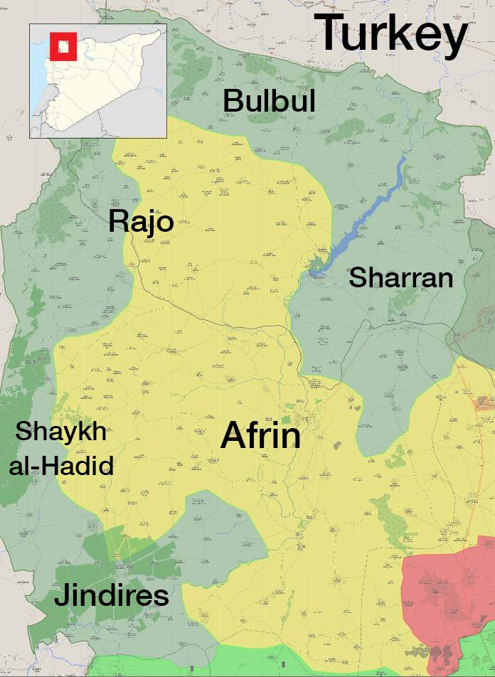
The military control map in Afrin, Northern Aleppo – March 3. 2018 (Livemap)
Major Strategic Positions Controlled by the “Free Army”
Rajo Town (The District’s Center)
The town of Rajo is located at the summit of 585 meters high mountain, sloping west words towards Palya Plain. The factions took it over on March 3. 2018.
Rajo is 25kilometers away from Afrin, towards the western north, and is one of the ancient areas in the region, distinct for the train station, through which the railway Rajo- Meidan Ekbis passes.
Rajo spreads over 352 square meters and, today, 45 towns and 20 farms are categorized under the Rajo district.
It shares borders with Turkey at its western and northern parts; from the east, it has borders with Bulbul district and Shaykh al-Hadid and Mebaatli from the south.
Shaykh al-Hadid (The Joint Area)
According to the field control map, 18 areas are affiliated to Shaykh al-Hadid district, including towns, villages and communes.
It shares borders with Turkey in the west, with Mebatli in the east and with Rajo district in the northern side, while it is bordered with Jindires in the south.
The military factions of the “Free Army” controlled it on March 4.2018, and, through it, they secured the road connecting Rajo district in the north and Jindires in the western south.
The First Time Bulbul is Controlled
The “Free Army” controlled Bulbul for the first-time on February 2. 2017, under a military operation, through which it secured Afrin’s northern borders with Turkey.
Bulbul district consists of 48 administrative communes and residential blocks, with the town of Bulbul as its center.
It is bordered by Sharran in the east and by Rajo district in the west, as well as Mebatli district in the south. As for the north, Bulbul shares borders with Turkey.
Bulbul city is located at a 50 kilometers distance from the city of Afrin and about 90 kilometers from Aleppo in the northwestern direction. Cyrrhus, a major archeological site and a tourism destination at the banks of the two rivers, Afrin and Sabûn, is located in its eastern part, over an area of about 12 kilometers.
Sharran (The Eastern Gate)
Sharran district includes 44 communes of residential blocks, with Sharran town as its center.
In the east it is bordered with the city of Azaz and the center of Afrin in the South, as well as Mebatli and Bulbul districts in the west and the Turkish borders in the north.
Sharran’s area is about 331.035 square kilometers, and it is 13 kilometers away from the city of Afrin towards the eastern north.
According to Activists, it contains an elementary, preparatory and a high school, in addition to an ancient mosque, a post and telephone center, as well as a health center, a recruitment center, a political party and a police station.
The military factions controlled it in March 6. 2018; it is considered as Afrin city’s eastern gate, with controlling it the road became open for the “Free Army” towards Afrin.
Sharran’s importance lies in its inclusion of the “strategic” troop camp of Kafr Janneh, categorized as one of the “Units’” major military cantonments in the area.
Jinidres (The Western Gate)
The “Free Army” factions controlled it on March 8. 2018, and it is considered as the second largest district in Afrin area.
Its strategic importance lies in the idea that it forms the knot of the major road between the Northern countryside of Idlib at the side of Atmeh, a border area with Turkey, and Afrin area.
As military sources have told Enab Baladi, the area separating Jindires from Afrin is relatively smooth if compared to other areas, and it is viewed as a gate to the city of Afrin in the western southern side.
if you think the article contain wrong information or you have additional details Send Correction
النسخة العربية من المقال
-
Follow us :


 More Politics
 Most viewed
- Potential Erdoğan-Assad meeting in Moscow: Talks of excluding Iran
- European countries call for re-evaluation of policy towards Syria
- After Turkey and the opposition, SDF shows willingness to dialogue with Syrian regime
- Al-Assad reproduces Constitutional Committee through People's Assembly
- After al-Hasakah, AANES releases prisoners in Raqqa