

Enab Baladi – Idlib
The concerns and fears of farmers in northwestern Syria increased after a series of landslides, faults, cracks, and sand emissions on the outskirts of the Orontes River in northwestern Syria, which left traces on their crops after a massive earthquake struck the region on February 6.
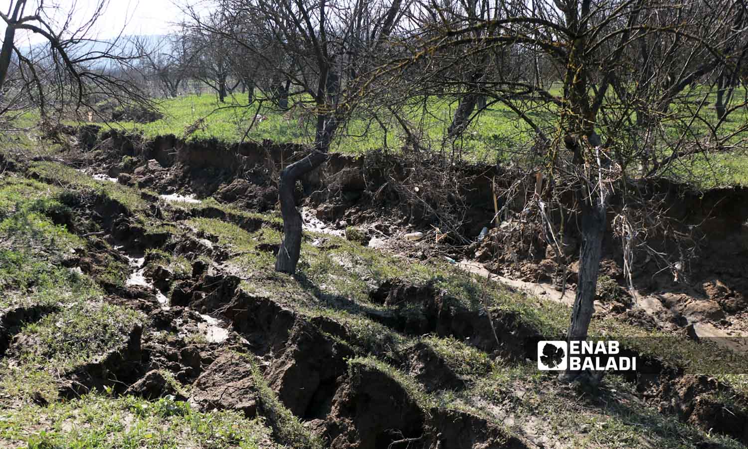
The soil was displaced in separate agricultural lands in the city of Darkush, which is located on both banks of the Orontes (Asi) River, and cracks appeared in the lands adjacent to the river, two to three meters wide and three to four meters deep.
The cracks showed new tunnels, and black sand came out of the ground in the form of volcano-like bubbles.
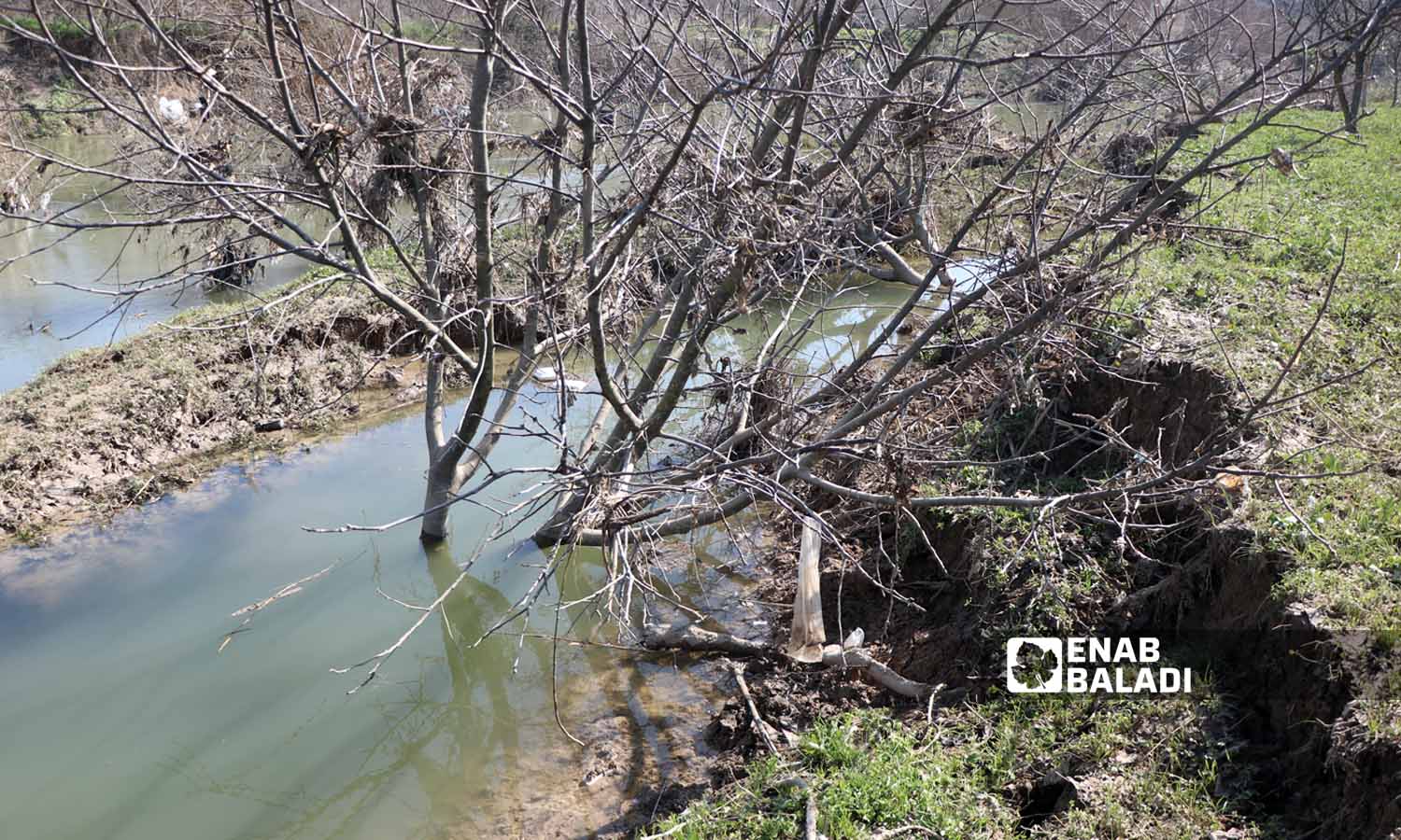
Abdul-Malik Dabel says that the sporadic cracks that appeared on his land in the city of Darkush exposed dozens of trees to damage, uprooting, and displacement towards the Orontes River.
“All trees near the Orontes River were affected of all kinds and moved towards the river, with the appearance of terrifying faults and cracks that farmers had not seen before,” he told Enab Baladi.
Dabel added that most farmers are ignorant of how to deal with these cracks, faults, and displacement in the soil, as the region has not witnessed any previous phenomena or cases of this kind.
For his part, Hassan Zaybak explained to Enab Baladi that dozens of trees in his land in Darkush have moved towards the river and that the cracks have left new tunnels in the form of watercourses, and black sand has emerged from the ground in a shape resembling a volcano.
Enab Baladi’s correspondent in Darkush reported that the damage affected hundreds of trees, the ages of which vary from young ones between two and three years to large ones between 15 and 20 years old.
He mentioned that the damage affected the lands extending along the banks of the Orontes River, including the village of al-Talul, which was also damaged by the river’s flooding of lands and residential neighborhoods on February 9.
Agricultural engineer Mousa al-Bakr told Enab Baladi that the cracks negatively affected the trees that were planted within the crack and soil fracture area, which led to their cutting or displacement.
Al-Bakr pointed out that the cracks do not have any future impact on crops, but dozens of trees were damaged.

Ground faults and landslides in agricultural lands towards the Orontes (Asi) River in Darkush, in the western countryside of Idlib, as a result of the earthquake that struck the region – February 17, 2023 (Enab Baladi – Mohammad Nasan Dabel)
Geophysicist Ali al-Shaher told Enab Baladi that the cracks are called local faults, and they are parallel to the course of the Orontes River.
These changes are called “dangerous earthquake companions,” and they only happen in the case of very severe earthquakes, al-Shaher added.
It is possible to take advantage of these faults, according to al-Shaher, by turning them into agricultural terraces, with caution because they may be unsafe with the continuation of soil collapses, according to al-Shaher.
Terrace farming aims to rearrange farmland and excavate and move the topsoil to form areas that can be cultivated. Terraces help control erosion and benefit soil conservation, restore vegetation, and enhance biodiversity.
Terrace setting up also prevents erosion of soil nutrients and vegetation removal by rain and helps to reduce soil erosion and water loss.
Water flows to the lower platforms when the upper platforms are filled with water, so the amount of water is more or less evenly distributed.
Terraces bring some environmental risks, as terraces can lead to saturation of the soil with rainwater, which may cause flooding during the rainy season, and terraces may sometimes cause mudslides if not managed well.
Terrace setting up also requires more labor and costs, and leads to a decrease in soil quality due to the process of “leaching” (soil loss of essential nutrients), says the geophysicist.
The devastating earthquake, whose epicenter was the Turkish state of Kahramanmaraş, with a magnitude of 7.7, followed by another earthquake in the same state with a magnitude of 7.6 at noon on the same day, was described as “one of the biggest disasters not only in the history of Turkey but also in the region and the world.”
The earthquake resulted in the deaths of more than 48,000 people in Turkey and Syria, in a toll that could rise.
The earthquake’s death toll in northwestern Syria reached a total of 2,274 and 12,400 injuries, with tens of thousands of families in need of shelter and medical treatment.
Some Turkish cities witnessed “mysterious” phenomena after the earthquake, including a huge sinkhole that opened up 37 meters wide and 12 meters deep in the Turkish Karapınar region of Konya state, which raised fears and confusion among the residents, with research centers denying the existence of a relationship between the crater and the earthquake.
Drone images captured in Kahramanmaraş state showed cracks along a fault line after deadly earthquakes that hit the region in early February. The first magnitude 7.7 quake caused a rupture approximately 190 miles long, according to the AFP. Also, landslides appeared across fields and roads, which led to the movement of buildings by meters in one direction.
Enab Baladi’s correspondent in Idlib, Mohammad Nasan Dabel, contributed to this report.
if you think the article contain wrong information or you have additional details Send Correction