

Via focused bombardment operations, Russian aircraft targeted bridges in the al-Ghab Plain in rural Hama, triggering a series of questions, on top of which is the following: Why at this specific time?
The bombardment, last week, covered bridges at the outskirts of the Sharia, al-Tweineh and Beit al-Rass, to which Assad’s forces cannot arrive.
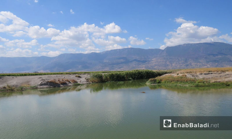
Since the beginning of the military campaign against the towns in the al-Ghab Plain in the Western countryside of Hama, the Syrian regime has placed its fundamental points on the Assi river’s bridges.
Assad’s forces took position at the al-Mahd bridge to the west of al-Suqaylabiyah city and placed the four bridges in the areas-held by the opposition in the al-Ghab Plain in the range of their weapons; the bridges are in the outskirts of the al-Tweineh, Sharia, al-Hwaiz and Beit al-Rass.
What Do You Know of al-Ghab Plain?
Prior to the fifties of the last century, al-Ghab Plain was a huge swamp, good for nothing but for fishing and catching birds.
However, the Syrian government, since 1958 to 1968 has cooperated with Italian and German companies to drain it through opening vertical and horizontal channels to regulate the disposal of the Assi river’s water and the abundant springs, as well as to build bridges on these channels.
The following successive governments have then distributed the lands to the people who housed the river’s two banks, to give the towns on the eastern side the title of opposition with the beginning of the revolution, while it gave the ones on the western side a contrary title for being loyalists; the latter are of a greater height of the rest of the plain, according to the “Free” Hama Governorate Council member, Samer Satouf.
The Importance of the Assi Bridges
The importance of the bridges lies in their being a connection between the people, most of whom have turned to agriculture and raising cattle and between their farms and lands, which made relinquishing theses bridges an impossible thing.
Abdulmueen al-Masry, a leader of the “Free Army”, told Enab Baladi that these bridges are located in the areas under the regime control. Some of them are one kilometer away from the points where its forces are positioned.
The reason why the regime decided to bombard these bridges and to target the passersby via snipers, especially farmers. If the regime manages to destroy these bridges, it would be able to separate its areas from those held by the opposition.
100 Thousand People are Threatened with Mass Exoduses
Samer Satouf, a member of “Free” Hama Council, said that with the break out of the revolution people became poorer, for 80% depends on the dairies and agricultural products’ market, which has changed to be less active.
The people are about to face a humanitarian crisis due to poverty, which might force them to conduct a mass exodus from the eastern part of the al-Ghab Plain, because the regime is repeatedly targeting the strategic bridges in the area.
According to Staouf, this campaign has one of two ends, either to separate the opposition-held areas from the loyalist ones or to impoverish the opposition and displace them.
Al-Masri for his part, believes that targeting bridges such as al-Tuwayni, Sharia, and Beit al-Rass results from the regime’s and the Russians fear of a military operation on the part of the opposition, in which the latter might attack towns, including al-kareem, Qabr Fidda, al-ashrafeh, al-Ramlah, Tamana al-Ghab, al-Darableh, al-Tuteh and al-Hakourah.
And added that the regime is seeking to conduct a demographic change by the expropriation of lands by the members of the National Defense, after the displacement of the people from the opposition-held towns.
The number of the people in the eastern bank of al-Ghab Plain is about 100 thousand persons, distributed on about 30 towns; they are threatened to lose their agricultural lands as a result for the bridges destruction.
The towns and areas of al-Ghab Plain are divided into three geographical areas, a western part, located at the slope of Lattakia mountains and al-Akrad mount, which Assad’s forces control 90% of.
The central part is located in the middle of al-Ghab Plain, starting from the al-Khandaq town in the south to the town of al-Hakoura in the north and all the towns in this area are under the control of Assad’s forces.
As for the western part, it is adjacent to the Shashabo and Zāwiya mountains, the latter’s towns and villages are all held by the opposition.
With the installation of monitoring points in the northern countryside of Aleppo, it is expected that the control map within the two banks would be drawn as such, awaiting new understandings concerning roads and crossing between the two sides.